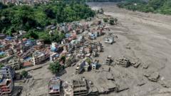
The flash floods that tore through the rugged borderlands of Nepal and Tibet did not arrive as a polite warning. They manifested as a vertical wall of mud, stone, and pulverized ice that erased bridges, swallowed multi-story buildings, and left hundreds missing before local authorities could even verify the telemetry. While initial headlines scrambled to point fingers at a minor 4.4-magnitude seismic event or a sudden glacial lake outburst, the structural reality of this catastrophe runs much deeper than a simple acts-of-god narrative. This disaster represents the terrifying convergence of high-altitude cryospheric collapse, transnational hydrological blind spots, and the aggressive expansion of fragile economic infrastructure into active hazard corridors.
Understanding the human and material toll requires looking past the superficial blame game currently playing out in regional parliaments. The torrent originated around the upper catchments of the Lhende and Bhote Koshi rivers, tearing down toward Rasuwa and the Trishuli basin with terrifying momentum. Critical infrastructure projects, including multiple operational and under-construction hydropower stations, were bypassed or pulverized in minutes. To trace why this happened, we have to examine the fragile mechanics of the third pole and the institutional failures that leave mountain communities completely exposed.
The Anatomy of an Unseen Collapse
When a mountain river swells catastrophically without a drop of rain falling in the immediate downstream valleys, analysts must look upward. Way upward. The Hindu Kush Himalaya region is warming at a rate well above the global average, fundamentally destabilizing steep rock faces and ancient ice masses that have remained frozen for millennia.
Initial satellite evaluations and local geological assessments point toward a complex sequence. An ice-rock avalanche or a sudden structural failure of an unstable mountain mass crashed directly into the Lhende Khola. This debris dammed the narrow channel instantly. Water pooled behind this unstable barrier, creating an accidental reservoir that lacked any spillway or controlled release mechanism. Minutes or hours later, the pressure overwhelmed the earthen and ice makeshift dam. The resulting surge carried the accumulated kinetic energy of millions of tons of slurry down a steep, narrow drop of nearly two thousand meters into lower valleys.
Seismographs recorded a minor tremor nearby around the same window, prompting early political statements blaming the earthquake directly. Yet geologists remain deeply skeptical that a modest 4.4 tremor was the sole primary architect of such localized destruction. More likely, the slope was already structurally compromised by continuous thermal stress, internal permafrost thaw, and seasonal seepage. The earthquake may have simply acted as the final microscopic straw on an overloaded geological camel's back.
The Transnational Information Black Hole
One of the most glaring vulnerabilities exposed by this tragedy is the persistent lack of real-time hydro-meteorological data sharing across the international border. Tibet sits at a much higher elevation within the Tibetan Plateau, controlling the upstream catchments of numerous river systems that flow aggressively southward into Nepal, and eventually into India.
When anomalous water behavior or blockages occur on the Chinese side of the border, downstream communities in Nepal rely on diplomatic channels and fragmented communication protocols to receive warnings. Minutes matter when a wall of water is traveling down a narrow canyon at highway speeds. Security camera footage recovered from border checkpoints showed residents scrambling for higher ground with mere seconds to spare.
Communication lines, customs infrastructure at major trading ports like Gyirong, and local police outposts were wiped out almost simultaneously. This isolation turned affected zones into information deserts. Search and rescue coordination became a logistical nightmare because the roads required to move heavy equipment were the exact things washed away by the torrent. When early warning systems depend on cross-border bureaucratic cooperation rather than automated, open-source sensor networks, catastrophe management becomes entirely reactive.
The Hydropower Paradox
Economic necessity in the Himalayas forces a dangerous gamble. The region holds immense green energy potential, with estimates suggesting hundreds of gigawatts of capacity tucked into its steep river valleys. Governments desperate for energy independence and revenue generation have greenlit dozens of run-of-the-river hydropower projects along these exact high-risk channels.
Projects like the Rasuwagadhi and Upper Trishuli installations are engineering marvels designed to harness steep drops in elevation. However, they are fundamentally vulnerable to the very nature of the mountains that power them. When a debris flow or glacial outburst occurs, concrete intakes are choked with silt, underground powerhouses are flooded, and penstocks are sheared like paper.
This creates a brutal economic paradox. The push for renewable energy to combat global climate change drives the rapid development of infrastructure in high-altitude zones. Yet that same infrastructure sits directly in the path of climate-amplified disasters. Insurance models for these assets are increasingly strained, and local populations bear the brunt of the risk while financial returns remain centralized. Developers frequently under-estimate cryospheric hazards during initial environmental impact assessments, treating glacial lake risks and ice avalanches as low-probability tail events rather than active, evolving threats.
Moving Past Superficial Mitigations
Treating disasters of this magnitude as isolated anomalies allows authorities to sidestep uncomfortable systemic reforms. Simply issuing temporary SMS alerts once a river has already begun to rise is no longer an adequate defense strategy for vulnerable settlements strung along the Trishuli and Gandak river basins.
Engineers and disaster risk reduction specialists argue for a complete overhaul of high-altitude hazard mapping. This requires continuous satellite radar interferometry to monitor shifting slopes and swelling high-altitude lakes before they fail, coupled with automated acoustic and pressure sensors anchored high in the remote ravines of Tibet and Nepal. More importantly, it demands institutional honesty from regional governments regarding zoning laws. Rebuilding destroyed settlements and tourist lodges in the exact same low-lying flood channels guarantees a repeat performance when the next seasonal thaw or slope failure occurs.
The rushing waters have receded from some of the worst-hit pockets, leaving behind thick layers of grey silt that mortgage the future of the valleys. Hundreds of families continue to wait for news of missing loved ones as rescue helicopters carve paths through the gray mountain air. Until the structural realities of a warming cryosphere and the complexities of transnational river governance are addressed with absolute candor, the Himalayan borderlands will remain a ticking clock disguised as a trade route.